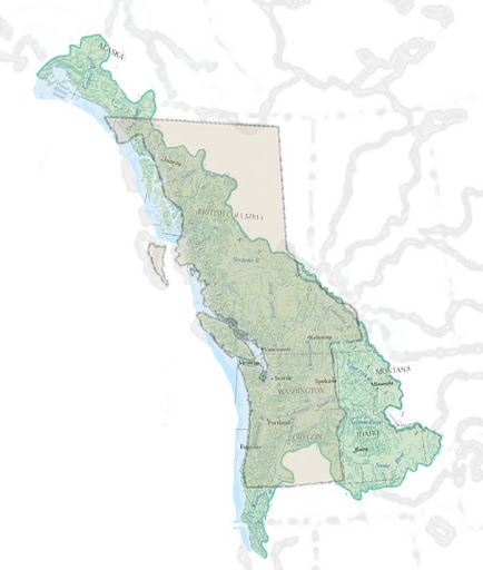
I recently came across a summary of Nine Nations of North America, written by Joel Garreau in 1981. In it, he argues that national and state borders are largely arbitrary, and he redrew the borders of North America according to what he thought were following cultural and economic lines. Thus, my home in Portland, Oregon was part of the nation of "Ecotopia". As an admirer of maps and geography, I was immediately drawn into the theme and thought the premise was brilliant. I live in a state and nation that have arbitrary borders that don't follow any particular logic. Big, square states dominate the western USA, cutting across rivers, mountains, and lakes like their borders were drawn by a child who never set foot on their ground. Why not take another look at better ways to administer land? It took me just a few seconds reviewing his map to decide that I disagreed with his rationale for borders. For starters, he left huge swaths of land empty of authority and completely left out what should be the main concern of administrative boundaries: water. Then it took me just a few more seconds to decide that I should perform the same exercise and draw my own nations of North America. Then it took me just one more second to decide that I should perform the exercise on the entire earth. Then it took me about 20 hours of work spread out over several weeks to finish the maps using Google Earth, and thus my thought experiment Twenty Nine Nations of the Earth was born. Water Management In older days it made sense for large rivers to act as borders, because they were hard to cross and the water was plentiful and clean, but today shared water resources creates mismanagement of a precious resource, resulting in conflict, inefficiency, and pollution. Yes water. Despite the appearance of plenty, water is a scarce and valuable resource. It has been and will be the source of immense conflict around the world. Aquifer depletion will reach an endgame over the next 25 years as half the world’s population will reach the bottoms of their wells. Just to name a few current examples · In California's central valley water is being pumped over the hills into Los Angeles and also diverted towards irrigating farms to such an extent that the reduced volume of the Sacramento river is causing the ocean to wash up into the valley and fish runs are almost entirely depleted. · By the time the Colorado river reaches Mexico, it’s just a trickle. After making electricity and being diverted for agricultural as it rolls southward, the largest canal in the US siphons off a huge chunk of the remaining river and pulls it into the Imperial Valley of California. Mexico gets almost nothing. · The Ogallala aquifer under the Great Plains of the United States, which is responsible for historic food production since WWII and currently 30% of the nation's irrigation, will be dry in about 25 years. · Lake Chad supplies four countries of Africa with water, but has mostly dried up in the past few decades, inciting violence over water rights and being declared an ecological catastrophe by the UN. · The Sea of Galilee supplies most of the fresh water for Israel, and when Syria began constructing a diversion of the headwaters of the Jordan river, 3 years later Israel captured the Golan Heights and continue to hold the area to this day. The final stretch of the Jordan, where Jesus was baptized, is now full of raw sewage as it dumps into the dead sea. · Egypt has claimed water rights to the Nile and may soon enter into conflict with countries of the upper Nile who plan on building hydroelectric plants and other water diversion. · In Spain, despite an attempt to control water use, many illegally dug wells are sucking the aquifers dry to grow cabbage and to water golf courses. · Saudi Arabia sits on a grand aquifer with more water than the Persian Gulf, and has been pumping it unsustainably to grow wheat and supply a booming population. The aquifer is halfway depleted and its refresh rate is so low that it is essentially non-replenishable. · The Caspian Sea is bordered by five countries and is almost entirely fed by the Volga River, which is in Russia. Diversion and release of the Volga waters have caused the sea to rise and fall over time, to the consternation of those who share its shores, and Russian contamination of the Volga is cited as the source of infectious diseases that have appeared around the Caspian. It’s clear that, 1) water management will become a high priority over time, 2) water rights should include the interests of all people that share a watershed, regardless of political boundaries and 3) the rights of future generations should be safeguarded. Similar principles can be applied to oil and gas deposits, as well as natural resources such as forests. These principles, along with transportation and population centers, were the principles behind my ideas for national borders. Federalism I don’t want anyone to take this too seriously, but at the same time nobody should immediately disregard this idea as the fanciful musings of a crazy person. Ask yourself this question: why is the USA the most successful and affluent country in the world? Most people wouldn’t say "federalism", but our system of administration plays an enormous role, possibly the greatest. Imagine the 50 states of the US as independent sovereign countries, each with its own military and currency. Nobody in Oregon can appreciate the value of not having to fend off militias from Idaho crossing the border, or the efficiency of shared national services that reduce the tax burden, or the federal initiatives that developed the dams on the Columbia River that provide electricity at the cheapest rates in the country. Now ask yourself this question: what does Africa need to pull itself out of abject poverty and militancy? Nobody I know would say federalism, but that’s exactly it. The borders of African states were drawn by European powers with the explicit intention of promoting division. Even now many European countries oppose efforts by the African Union to form a continent-wide political unity, and now China has moved in to begin raping the land of resources. The AU has a mandate to "promote peace, security, and stability on the continent", and retains the right to intervene in member states in circumstances of unconstitutional changes of government, war crimes, genocide, and crimes against humanity. This would just be a talking shop like the United Nations, but the AU already has a military deployed in Sudan’s Darfur region and another campaign ramping up in Mogadishu. Africa won’t bring itself out of its current mess by middle-class Americans donating $10 a month to starving children in Somalia, or missionaries building a hospital in the Congo, but it can be successful by pooling resources and creating a level of sovereignty above individual states that will crush warlordism and establish a strong currency. Nationalism In past ages the racism that now seems so abhorrent to all but a handful of the world’s citizens was part of the social reality of the time. Its falsehood is now clearly recognized. In the future nationalism will likewise have abated to the point where people look down upon the thought of promoting the people within one arbitrary political border over the people of another arbitrary political border. The same principle underlies both racism and nationalism, but nationalism is still part of the current social reality that will naturally fade away when its falsehood is clearly recognized and the unity of humankind is firmly established. When this happens, as I believe it must, it will be possible for political borders to be debated and redrawn with a focus on the proper administration of transportation and ecological boundaries. This re-drawing will itself promote efficiency of resources and environmental sustainability, and the act of reorganization will be the source of economic and cultural growth. All this is to say that while my little project here shouldn’t be taken too seriously, the principles behind it are profound. There are four primary administrative divisions in most countries of the world. First there is the nation or country, then the state or province, then the county or principality, then the city or town. These maps draw national borders, presumably with each containing many states within each, but I left out the state borders on all but my own home nation, which I’m more familiar with. I’ll go into detail about my home area, then I’ll just provide a brief description of all the others. The names of each nation are the first thing that came to mind. There is one consideration in borders that I considered but didn't incorporate due to the amount of work required. Mountains make up most of my borders, but they don't make good border checkpoints. Assuming that each nation would want to control immigration, the borders would have to be adjusted to consider human transportation. Minor adjustments could be made along major highways so that where highways and national borders intersect, they can be conveniently located in valleys instead of mountaintops. The original Oregon Country was jointly administered by the US and Britain, and covered the watersheds of the Columbia and Fraser rivers. The area has a natural cohesion and is surrounded by mountains or desert on all sides. The land was hotly debated and then divided between the two powers along the 49th parallel, a totally arbitrary division running all the way from the Great Lakes. The unsound border caused some problems as it hit the Pacific, cutting right through Vancouver Island and the Puget Sound. Canada claimed the entire island and the US demanded that the 49th parallel be maintained as the border. This dispute caused a war that resulted in the death of a pig (no humans). The island was ceded to Canada, but the US held onto the San Juan islands and the tiny exclave of Point Roberts that happened to be south of the 49th parallel. This division also meant that the Fraser River delta was politically separate from the rest of the territory, despite the obvious cultural and geographical similarities. There is a distinct common culture that runs from Vancouver to Seattle, Tacoma, Olympia, Portland, Salem, and Eugene, all of which are tied together with Interstate-5. This is the "heartland" of a distinct independence movement called "Cascadia", taking its name from the Cascade mountain range that runs north to south through the area. The approach behind Cascadia is similar to my idea that the current borders are arbitrary and need to be redrawn to account for ecological bioregions. For my map, I took this highly populated area and grouped it with some of the unpopulated lands of the North. The three Canadian arctic territories currently represent 3.5 million square kilometers, with a population of just 110 thousand. This area can’t simply be left as an "empty quarter" as Joel Garreau put it. Areas like this should be administered by a few population centers to provide the human resources required for proper management of resources, while giving some higher level of autonomy for those actually living there. I divided Cascadia into nine states, each representing a bioregion. The state of Oregon is the Rogue River, Willamette River, and lower Columbia watersheds, and the rest of the Columbia is divided into three other states. The state of Jefferson (taking its name from an actual state-hood movement) represents the middle Columbia and its tributaries east of the Cascades, including the Deschutes River. The state of Idaho now represents the Snake River watershed, which gathers a large area up to the continental divide near Yellowstone. Above that is Montana, representing the headwaters of the Columbia. The area around the Puget Sound and Olympic Peninsula make up the new state of Washington, and to the north the Fraser river watershed and several smaller rivers make the state of Vancouver. The new Alaska is shortened to the southern coast, and to the north is the Yukon. The state of Mackenzie follows the Mackenzie River watershed, which swallows up a huge portion of northern lands and dumps its water into the Arctic Ocean. Besides the cities already mentioned, Cascadia has sizeable populations in Pasco, Kennewick, Spokane, Boise, Anchorage, and Fairbanks. The nation of Cascadia, as with all the nations I created, would be a powerhouse. The economy of Seattle, its largest city, is currently greater than that of Venezuela, Columbia, or Thailand. Its vast forests, petroleum reserves, and capacity for hydro power represent its greatest natural resources, and its industry is home for Microsoft, Boeing, and Nike. The Nation of California follows the great Colorado River, the California Central Valley and the gulf of Baja California. A great deal of it is covered by desert that would be uninhabitable except for the Colorado River; Las Vegas is a clear example of that. Any water diverted or used for power must be accounted for, but if sovereignty of the river is shared, as is currently, then anyone upstream could siphon off the water into profitable crops to the detriment of anyone downstream, as is done currently. I also see a natural cohesion in these boundaries following cultural and travel lines. For example, the current state of Colorado has three distinctly different ecosystems, and in its current form doesn't fit neatly into groupings of other states. If split along the continental divide, the land fits nicely into bioregions. The new nation of Canada follows the watershed of the Great Lakes, or any water that dumps into Hudson Bay. It also extends into the islands of the far north and includes all of Greenland. Look closely and you'll see that Chicago and the industrial cities of Milwaukie and Detroit are all part of Canada, adding to Toronto, Ottawa, and Montreal. The farmers in southern Illinois are tied to the plains instead of the lakes. The joining together of the Great Lakes is important for ecological reasons. It only takes one kid peeing to ruin a day at the pool, and it only takes one factory along the border of any lake to destroy the ecosystem for everyone else. Currently nobody is in charge of the Great Lakes, at least not effectively, and the absence of authority has allowed environmental destruction to persist long after it should. The western panhandle is actually the watershed of lake Winnepeg, and boasts the cities of Edmunton, Calgary and Saskatoon, representing millions of people and an important economic area. With the thawing of arctic ice and the opening of the northwest passage in the last few years, this nation should see nothing but green pastures in its future. Enough food is currently grown in the Mississippi watershed to feed the entire world, notwithstanding transportation. The nation of Mississippi stretches from Denver to Pittsburg, Bismarck to Dallas, and New Orleans to the continental divide, not to mention Oklahoma City, Memphis, Nashville, Indianapolis, and Columbus. Its economic power is undoubtedly vast, and the administration of water rights will become increasingly important as one of the largest aquifers in the world begins to dry up right in the center of this country. This nation will also be responsible for the pesticide runoff into the gulf that is currently causing dead zones. I'm sure someone out there can come up with a better name than "New England", but this is roughly the original thirteen British colonies of America. This region has clear cultural and transportation ties, while the ecosystem similarity is mostly related to it representing the coastal region, as opposed to the watershed of a major river. Texans will have a hard time accepting it, but the state doesn't represent any logical cohesion other than cultural history. The Rio Grande currently represents a border, and it should be the center of a region that has similar ecology. The deserts around Albuquerque, El Paso, Juarez, San Antonio, are now grouped with Houston, Mexico City, and most of current Mexico. When I was 14 I actually drove through California, Arizona, New Mexico, Texas, and into Mexico as far as Mexico city and La Huasteca. Although I've never been to western Mexico, I'm pretty confident in the border of this nation as representing logical administration. Anyone who's been to southern Florida knows that it's nothing like the rest of the United States. In the nation of the Caribbean, it's tied together with all the islands and central America extending all the way to the Orinoco River in current Venezuela. Even though there is no watershed, the islands of the Caribbean need a regional administration, or some kind of federal grouping. In this region the island of Cuba will be a strong presence, as well as the area of current Venezuela and Columbia. The Panama Canal represents a major resource of the Caribbean, as well as some gulf oil deposits, fishing, and of course tourism. I admit, South America took quite a bit of consideration. The Amazon represents an obvious large eco-region, but its western slope in the Andes mountains runs very close to the Pacific Ocean, and there are virtually no population centers in the Amazon basin. The major cities are all along the rings of the watershed, and those cities might be inclined to be grouped politically with closer cities. I decided to stick to the basis of watershed, which means cities like La Paz and Santa Cruz are in the nation with Georgetown, Paramaribo, and Cayenne along the northeast coast, with no major transportation routes connecting them. This seems appropriate as long as there is an established capital, and the nation would continue to be broken into somewhat autonomous states. The reason I stuck with watershed is the same as reasons already given to the importance of water. Santa Cruz has a major river flowing through it that feeds into the Amazon basin, and to ally it politically with another power means that water diversion and pollution would not be managed on the same water source. Political alignment can work between distant lands as long as the constitution is set up similar to the United States, where individual states have a shared sovereignty, and clearly defined roles. A "light" federal system would be ideal. Patagonia represents the cultural and economic centers that make current Brazil and Argentina noteworthy. Its coastline is dotted with Buenos Aires, Sao Paulo, and Rio de Janeiro, and its inland represents vast agricultural potential. Its western border is defined by the watershed of the Rio de Plata, which spills into the Atlantic near Buenos Aires. The nation of Peru covers the Andes mountains and everything west, along with the southern tip of the continent. Despite its narrowness, there are actually many cultural similarities that run through the mountains and coastal lands. Major cities include Santiago, Lima, and Quito. The nation has exclusive use of a great area of the Pacific, and its territory includes the Galapagos islands. The first of the new African nations is South Africa, which covers an enormous and plentiful land, and includes several population centers. It also is home to the world's largest known deposits of platinum, chromium, vanadium, and cobalt, along with lesser amounts of diamonds, gold, titanium, iron, and uranium. The ecology of South Africa is not uniform, but its cohesiveness comes from it being the horn of Africa. The border I've drawn almost exactly follows the Southern African Customs Union, a loose economic grouping of countries similar to the beginnings of the European Union. Making the Congo region a single nation is actually much easier than for the Amazon. The Congo has several centrally located cities that already govern the watershed with some minor variations. The main concern is Burundi and Rwanda on the eastern side, which run along the Great Rift Valley. However, both Burundi and Rwanda are some of the smallest countries in Africa, and the lack of higher authority in the area has resulted in genocidal wars, and massive misuse of resources. The countries were arbitrarily made by European powers, and the people in the area would be best served by being split along natural borders into parts of much larger nations. Lake Chad is another example of misuse of water rights. The several nations that currently border this endorheic lake all rely heavily on it for their water supply. The mismanagement of it has led to its steady disappearance, which is at the heart of the unrest in Darfur. Providing a central authority over the watershed of the lake is essential for the long term stability of central Africa. The strip between Lake Chad and the Atlantic is what remains between the Congo and the Niger watersheds. The Niger River is the largest in western Africa, and snakes its way westward along the edge of the Sahara desert. Both the coastal and inland cities of the nation of Niger have some of the greatest potential in all of Africa to create a booming economy and nation. They are currently sorely lacking in success due to political disunity and poverty. Northwestern Africa was always referred to as the Maghreb (western) part of the Islamic world, and the term is still used to this day. Although the Sahara desert doesn't have much to offer in the way of population and resources, the coastal cities, particularly Tripoli, Tunis, Alger, and much of Morocco have strong populations and some natural resources. If you look closely, this nation also has control of Gibraltar, and thus the narrow passageway to the Mediterranean. It's only been a century since the clear discovery of the true source of the Nile River, but it didn't take long to cause controversy. Egypt's attempt to build the Aswan dam controlled the periodic flooding of the river, and made some power at the same time, but it also stopped the periodic silting of the banks of the river, which caused the fertile ground. In more recent years Egypt has become very blatant in claiming exclusive rights to the water of the Nile, just as Ethiopia and other countries are constructing water diversion projects that could leave Egypt barren. Clearly the entire Nile River watershed needs to be grouped together politically, if for no other reason than the incredibly valuable resources of the river. And if these are grouped together, it makes sense to add the area bordering the Red Sea to this federation, since the Suez canal connects it to the Mediterranean. The Nation of Europa encompasses every last bit of European land whose water drains into the Atlantic. This actually leaves many cultural and transportation ties intact, since past empires largely had to follow coastlines and were thwarted by large mountains. This nation has no shortage of population and economic capacity. It is the heartland of western civilization, with cities such as Lisbon, Madrid, Paris, London, Brusseles, Berlin, Prague, Warsaw, and St Petersburg. It also has surprisingly large petroleum deposits in the North Sea. The Mediterranean coastline represents a frequently conquered land that was ruled for centuries by Romans, Byzantines, and later Ottomans. The region has clear social and economic ties, and even similar ecosystem. Included in its boundaries is the Dardanelles, the strait that connects the Mediterranean and Black Seas. Among its major cities, it boasts Barcelona, Marseilles, Rome, Athens, Istanbul, Ankara, Damascus, and Jerusalem. The Danube River drains a large part central Europe into the Black Sea. This area has always been historically linked together, at times being dominated by Austria, Hungary, Romania, and even Russia. It naturally becomes allied together with other lands that drain into the Black Sea, mainly parts of Poland and most of the Ukraine. The Caspian Sea has an interesting ecology. It is endorheic, so it doesn't drain into the ocean, and it is fed almost entirely from the Volga River, which runs through the heartland of Russia. It makes sense to tie the area together with the watershed of the Aral Sea, which collects from central Asia. This area has always had cultural ties to Moscow, which itself was founded by Mongol traders from central Asia. The Aral sea is another example of water mismanagement. Its endorheic basin is split between several dry nations, and it has largely dried up in recent decades. Another endorheic basin just to the East could also be grouped into the Caspian nation, but it seemed more appropriate for it to be with Siberia, otherwise a large section of arctic lands would have a very small population. On the southern end of the nation of Siberia, Lake Balquash is an endorheic lake that collects water from northern central Asia. Just to its north, the Ob and Dvina Rivers have large basins that drain into the Arctic Ocean. The eastern border is defined by the Yenisei River, which also drains into the Arctic and has its headwaters near Lake Baikal, the oldest, deepest, and second most voluminous lake in the world (second to the Caspian). This nation is admittedly lacking in human resources. Its main cities will obviously be in the South, mostly in central Asia, but its northern territories are resource rich, and the thawing of the Arctic may play out well for this nation also. The nation of Iran follows roughly the old Persian Empire. The entire Persian gulf, with its immense capacity for energy resources, is all under a single authority. Also are the rivers that pour into the gulf that are currently part of disputes of water rights between Iraq and Turkey. When this region is politically coherent, civilization here will flourish. Major cities include Baghdad, Tabriz, Tehran, Shiraz, Basra, Kuwait, Riyadh, Dubai, and Esfahan. It also includes the southern shore of the Caspian, which has only a very small watershed that drains into the Caspian, and is much more culturally allied with Tehran. The border between the current countries of Afghanistan and Pakistan were drawn by a British man who never visited the area, yet they persist to this day. Afghanistan is currently a huge, mostly impassable mountain range surrounded on three sides by flat dry land. The mountain range represents the western border of the new nation of India, stretching all the way across the sub-continent into current Burma, and includes the watershed of the Indus and Brahmaputra Rivers, which stretch all the way around the Himalayas into Tibet. The islands of the Maldives are also included. The Indus Valley represents one of the cradles of civilization and in ancient times hosted the largest cities in the world. It is almost certainly the most populous of any of the 29 nations, and has a strong agricultural base. Southeast Asia has an interesting terrain. There is a stretch of land high up in the mountains where three major rivers run parallel to each other for a short time before diverging into three completely different seas. The Salween runs southwest through Burma and into the Indian Ocean; the Mekong runs southeast through Laos, Thailand, Cambodia, and into the South China Sea in Vietnam; the Yangtze runs east through the Sichuan basin and into the East China Sea. The need to manage the shared resource of the Mekong flowing through six countries has already caused controversy. China has begun construction of three dams on its headwaters that will threaten the livelihoods of all those living on its lower reaches. The lands of current Cambodia and Thailand have seen the rising and falling of great civilization over time, and combining them with Vietnam and the prosperous Yangtze and Pearl watersheds seems like a proper match. There is already extensive cultural mixing between southeast Asian countries and southern China. For lack of a better name, I called this Southeast Asia. Maybe Siam would work? The new nation of Indonesia encompasses Malaysia, Indonesia, the Philippines, and some other small islands. This seemed like an obvious fit for a nation, although I debated how much of Malaysia should be associated with the islands. This land has rich biodiversity, especially on the main islands of Java, Sumatra, Borneo, and Bali. Here you'll find a rhinoceros, orangutan, and an elephant romping around the forest, although their numbers are dwindling. The human population is doing much better. Malaysia, Indonesia, Singapore, and the Philippines have about 350 million people, larger than the current United States, and a combined GDP of about $1.75 trillion. Australia is a continent and country. The only change here is to group it with New Zealand, which doesn't fit as well into the Pacific Islands. Given the land and cultural resources, I think this nation has sufficient means to compete with the rest of the world and administer its affairs. The Hawaiian islands are the most isolated grouping of islands on earth, and didn't have any mammals or edible vegetation on them, but that didn't stop some Polynesians two thousand years ago from setting off on an adventure in advanced boats fully stocked with plants, animals and women. Hawai'i should naturally be grouped with the rest of the Polynesian Islands in a large nation with similar culture and ecosystems. Many of these islands are already grouped into political federations, such as the Federated States of Micronesia, Cook Islands, Solomon Islands, Kiribati, and French Polynesia. These, along with New Guinea, could easily represent individual states of a federal system for the larger nation to combine resources. The Yellow River, representing another historic cradle of civilization, rolls across the heartland of the oldest definition of China and dumps its water into the Yellow Sea. The headwaters of this river extend all the way up into Tibet. The far western area is the large endorheic Tarim Basin, the bulk of Xinjiang autonomous region and a major part of the old Silk Road. The Tarim Basin is most closely associated with northern China and Mongolia, so for this reason they are part of the same nation. Also noteworthy is the inclusion of most of Korea. Chinese people will immediately notice the division of China through the coastal plain as a grievous error, but anyone who has been to China also knows of a clear north/south cultural and linguistic divide, not to mention the obvious ecological differences. Nationalism has to fall for the Chinese too! The last nation is Japan, tied together with the Amur and the Lena Rivers, and some uninhabited arctic lands. The powerhouse of this nation is obviously the Japanese islands, but the continental land includes the Chinese city of Harbin, and the Russian port city of Vladivostok, connected to the Trans-Siberian Railroad Similar to Cascadia, the northern lands need to be part of a nation with significant human resources for administration and industry. For the land in the far northeast of Asia, it seems more logical to group it with a power in the Pacific Ocean, instead of Russia. All the images used here can be seen in this Picasa album. If you want the Google Earth files, post your email address.
Independence Movement


04 October 2010
29 Nations of the Earth

Cascadian
Cascadia
Subscribe to:
Post Comments (Atom)
We live in a patch-work world of illogically divided states. But I think to a great extent we already live in the world described by Baha'u'llah in the expression "the earth is but one country and mankind its citizens."
ReplyDeleteJust think about anytime that two countries have a border dispute. It has global consequences, so half the world has to weigh in anyway. Try to imagine diplomats from the US, EU, and China all agreeing that what happens in Kashmir is just between Pakistan and India and irrelevant to everyone else. It would never happen.
So since we're thinking about nation-level governance at a global scale anyway, we might as well get creative and try new things. And by "we" I of course mean all the peoples of the world. Devising new patterns of civil governance for the world would be perhaps the largest undertakings in human history. It would require unprecedented levels of participation to make it work.
Another thing that this got me thinking about is that we don't need to use the same borders for all the same issues. For example, there could be a political entity for all the Caribbean tasked with dealing with hurricanes on a holistic basis. But for education, there might be different borders and different organizations. After all, Tampa and Porte-au-Prince will be dealing with very different educational issues for the foreseeable future. So it might not make sense to lump them together in one political unit.
All of this is, of course, speculation. But it's very helpful to think outside the box of what already exists. Humanity, it seems, tends to walk backwards through history, highly aware of the past and everything that happened then, but generally oblivious about what lies in the path ahead of it. So it's good to take a chisel to our unquestioned assumptions every once in awhile.
This is incredibly impressive and quite an amazing thought piece. Thank you so much for taking on this project and posting it. As a Geographer this is like candy :)
ReplyDeleteI think that a lot of what needs to be done to help people both materially and spiritually can be done before this and through people becoming more equal and more welcomed for working in other countries, as well as settling long-standing disputes, a vast reorganization of cultures will occur and a shift in economic realities that will require completely redrawing these maps. There also might have to be settled long-standing misplacements of peoples due to conflicts from centuries ago that are still creating antagonism between peoples and might best be settled by solving the original difficulty, which could simply happen on the personal level through spiritual development, still creating great changes in culture. What if the Chinese all commute to Russia for work, or if more Italians than natives end up in Algeria? What if the European Australians gave the land back to the Aborigines, as they have been asking? What if Persia was no longer an Islamic majority? What if America had more Mexicans in it than Europeans? Or the Russians moved back into Alaska? If we are not so picky about borders I do not know what other reorganizations might take place. Also, Pakistan exists as a separate country currently for a good reason. They separated from India because all the Muslims live there and the Hindus in India (Originally Pakistan and Bangladesh were one country and they were East Pakistan and West Pakistan). If religious circumstances changed that might change. Overall I do not think we need to worry about border right now. As we work to get along we will sort it out.
ReplyDeleteIn a community I am involved in there was a large community that was split up according to county lines and part of it was far away from the rest but they saw people in another community more often, so they asked to be split apart and join the other community and it was done. Some of this seems hopeful though.
I really like this post a lot, I don't know how practical it is politically in the short term, but it makes a lot more sense to organize nations how you describe. Mr. Cat's point about there being different borders for different issues also makes a lot of sense. I like the idea of a holon, everything is a whole entity in and of itself, but it is also composed of parts and is also itself a part of something larger. In this case each nation would "exist" for a specific reason, and each region might be part of many different nation-reasons.
ReplyDeleteA friend commented that my maps don't include aquifer basins, which don't always overlap with major watersheds. I think he's right that this information should be included in politically organized bioregions, but there doesn't seem to be good documentation of aquifers and their attributes. It becomes very complicated when you consider hydrology, cause some aquifers are much more porous than others, and some have a very slow seepage rate. They don't all act like underground lakes, and their connectedness is not always clear.
ReplyDeleteI found this map that shows some major aquifer boundaries, but as you can see, it's complicated. I noticed that in general they follow river basin boundaries, so this isn't a huge change from the maps I drew.
http://www.whymap.org/cln_092/nn_1055978/whymap/EN/Downloads/Global__maps/whymap__125__pdf,templateId=raw,property=publicationFile.pdf/whymap_125_pdf.pdf
I would like to download the google earth files.
ReplyDeleteHi Cliff. Comments are moderated, so just post your email address. Only I will see it. I'll send you the file and delete the comment.
DeleteInteresting map of US states by equal population:
ReplyDeletehttp://fakeisthenewreal.org/reform/
Not surprised to find you on here. Hi Bryan!
DeleteJust stumbled across your blog, which I consider to be very interesting and thoughtful and I find this particular article very, very thought-provoking. In the near term, unfortunately, I see states and nations becoming more fragmented. In my state of Wisconsin, there has been great division politically over the last 2 years, and sometimes, as a Madison WI resident I will run into someone from another part of the state who will insist that Madison isn't part of Wisconsin. (Certainly the culture here in Madison is in many ways unique to Wisconsin).
ReplyDeleteSometimes I think that the only way to stop this internecine warfare is to give localities as much autonomy as possible so that they don't feel as threatened culturally or otherwise by their neighbors, and maybe from that place the nations as you describe them can be reconstituted, with the default being local governance unless certain issues--such as water allocation--need to be worked out regionally or nationally. Even then, I would see the potential for some ugly fights unless we as a human race evolve. I wonder if there are resources besides water that need to be taken into consideration?
Here is another attempt to redraw north America along cultural lines, similar to Joel Garreau. This one is by Collin Woodard:
ReplyDeletehttp://www.npr.org/2013/11/11/244527860/forget-the-50-states-u-s-is-really-11-nations-says-author
This is so awesome! I was like, I want to be friends with this person! Then I scroll down and see that its Bryan Donaldson. I knew you were awesome, but now you're so totally super OMG yeehaw chocolate and snorkeling awesome!
ReplyDeleteI'm saving this. Thanks bro! PS. I'm glad you made all of the Pacific Islands one section. I'm cool with that. :)
Dope. Make it so. :)
ReplyDelete